From August 5th-9th, my buddy Dave and I traversed the Elk Park to Needleton loop within the Weminuche Wilderness. We had planned this trip for months and I had been dreaming of it for most of the winter. Since moving to southwest Colorado, the Weminuche had been on my mind. I had done a few day hikes, but those never compare to an extended backpacking trip. Thoughts of alpine lakes, endless views, and a deep wilderness experience kept me company throughout most of the winter this year. Like most folks that do this trip, we decided on doing this particular loop due to accessibility via the very cool restored coal-powered Durango Silverton Narrow Gauge Railroad. We arrived in Durango early, stocked up on coffee and bagels, and hit the train. The ride is slow and smoky but gorgeous and a pretty fun and unique way to start a 5 day trip in the woods.

The ride is slow and sooty and other than the crying kids that overpopulated our car, the ride really was wonderful. With about five minutes to go before arriving at Elk Park, one of conductors gather all of the backpackers and ask you to head to the front of the train. When we arrive they unload our gear from the storage compartment and off we went. At Elk Park we were with one solo hiker and 2 other groups (one from BPL!). The faces on the tourists as the train started up were quit priceless. I assume they thought we were all crazy – we were after all in the middle of nowhere. Someone even threw a box of cracker jacks at us thinking we would probably need the food.

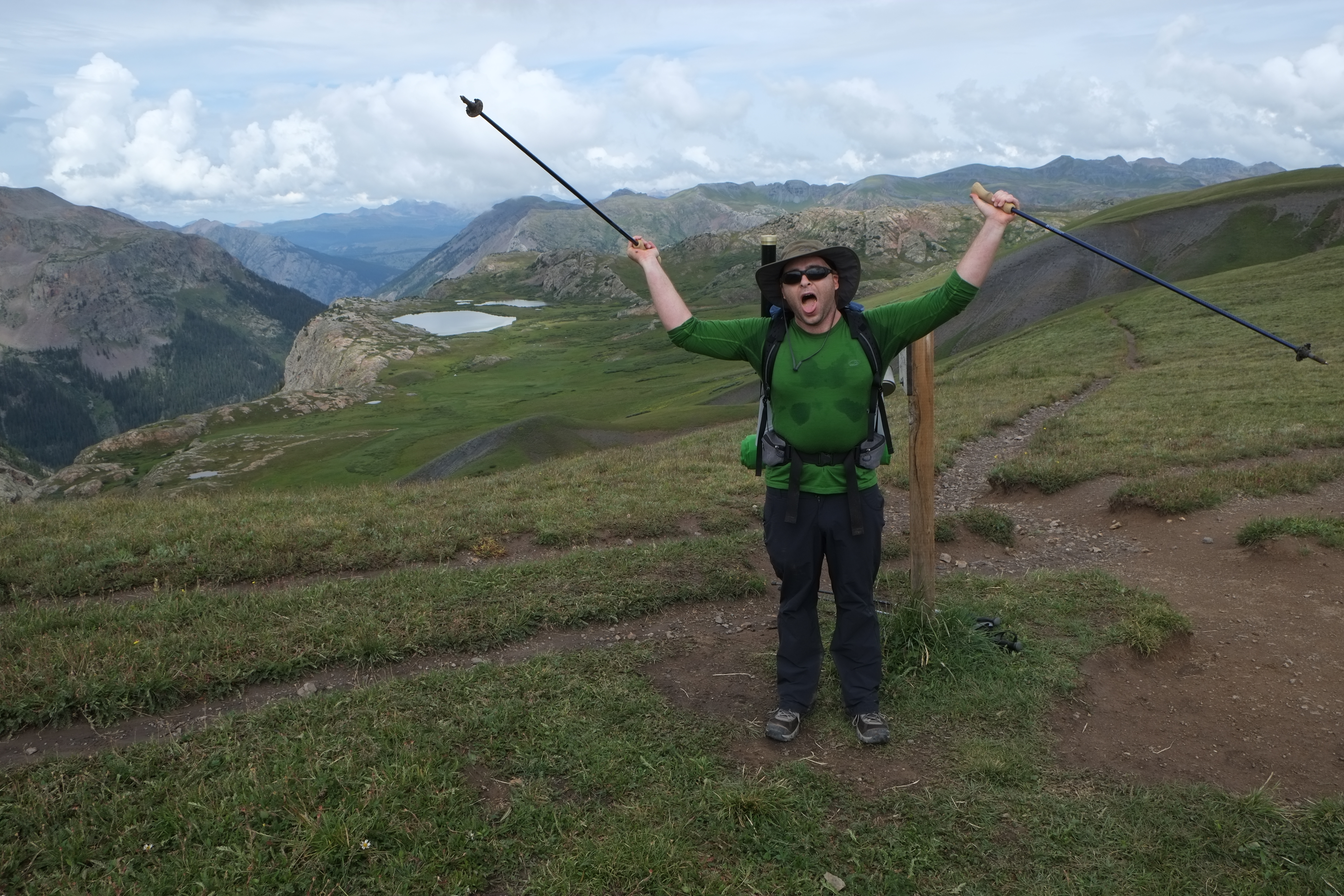
As we watched the train head further north to Silverton, Dave seemed a bit nervous. This was his first trip to the rocky mountains, his first time in a very remote wilderness area, and his first extended backpacking trip. In the end, he did amazing, but at this point….it was clear that excitement was being overtaken by nervousness.

Day 1 (Approximately 5 miles)
The loop begins on an easy stretch that follows Elk Creek up hill towards the Continental Divide. It’s heavily forested along the whole way with small glimpses of the creek below and seldom an open view. I love this kind of hiking as it reminds a bit of New England – the intimate forest traverse. This section of the trail is part of the Colorado Trail, which was a neat experience. Needless to say, it whetted my appetite for what may be a 2014 summer adventure. As we were climbing Elk Creek the clouds closed in and we got our first rain storm. It would become a constant on this trip; lightning, thunder, and all-day rain. For the two days that Dave was in Dolores and Durango before our hike, every person we talked to about our plans said essentially, “Prepare to get wet.” I’m not sure Dave fully understood the glory of monsoon season in southwest Colorado. He sure got a good taste of it. Neither of us had a dry piece of gear by the end of trip.
After about five miles I was ready to hike more, but with more dark clouds heading our way, and Dave wisely insisting we stop, we backtracked a bit and found a nice campsite. This was the first of two times that Dave’s instincts saved us some trouble. By the end of that first day, Dave was having doubts about whether he could complete the trip on time and make the train as planned. I knew he could do it, but he wasn’t so sure.


We ate quick due to an imminent storm and darkness began with lightning striking all around us – then it was calm – and then it began again. We were in the trees pretty down low; nonetheless there was usually just one or two seconds between lightning and thunder. Lightning was clearly striking the peaks just above us which sounds a lot scarier than it actually is. Every 30 minutes or so, we yelled over to each other’s tent to see how the other person was doing; it was that crazy of a storm. I didn’t get much sleep that first night. I assume Dave didn’t either. However, by morning, Dave decided he wanted to go for it. I was ecstatic and ready to walk.
Day 2 (Approximately 6 miles mostly off trail)
After the night of constant lightning and heavy rains, we were ready to walk off the cold. We packed up our soaked tents and started heading towards the Continental Divide. The trail climbed quickly offering impressive views of Vestal Basin, a popular area for peak baggers. After passing the Vestal Basin cutoff, the trail ascends to an alpine scree field filled with Pikas, which we thoroughly enjoyed watching. On this section of the trail you are basically following Elk Creek to its source (Eldorado Lake) but then you keep climbing up an incredible deeply green grassy area to reach the Continental Divide.


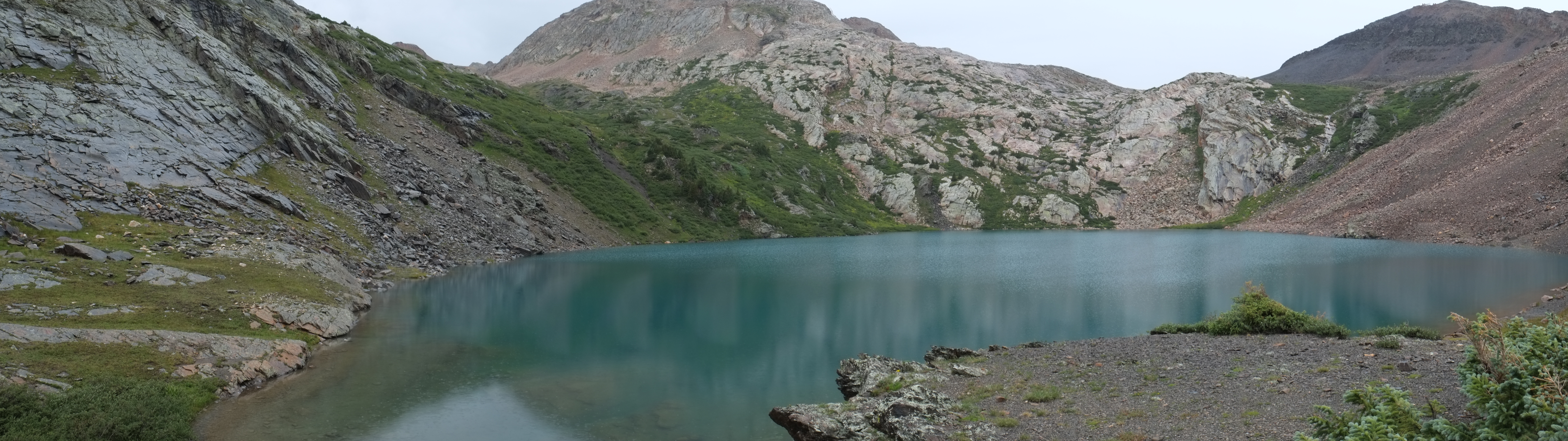
When we got to the Continental Divide we made a wrong turn. I knew the direction we wanted to go in, which was south so I didn’t consult the map. The route was clear in my mind – it basically looks like a backwards C with only a few junctions. I failed however to remember that to get south (on trail) you must travel north on the Colorado Trail before hitting the Continental Divide Trail and then head south past Kite Lake before connecting with Vallecito Trail. Luckily, the mishap turned into one of the more fun adventures on the trip. When Dave planned this trip, I promised a bunch of alpine lakes with fishing involved. When we settled on moving forward with our original plan to do the whole loop rather than go back to the train, I decided that we would have to forego the alpine lakes because most of them involved lengthy side trips up drainages which added serious milage. Our goal now was to just get to the train on time. While the fishing never really panned out, this wrong turn did get us to two incredible alpine lakes off trail – Eldorado Lake (12,500′) and Vallecito Lake (12,070′). I also got to experience my first extended leg of backpacking off-trail. Happily we found our way back on trail about 5 hours later.

As we were climbing towards Eldorado lake we ran into a group of folks who had camped the previous the night at the lake. I asked how they fared in the storm. The guy’s response was priceless and one I’ll never forget. In a very excited tone he relayed to me that the lightning/thunder gap was never more than a tenth of a second (essentially right above his head). He had a huge smile on his face and said, “You just gotta hope it’s not your day.” Dave and I smiled at each other and thought the guy was rather badass. Perhaps a risky attitude, but he was at least 65 years old and looked like a seasoned backpacker. I could tell he had been in some big storms before and here he was telling us about it. My attitude on the other hand is one of reducing risk and being safe. On this trip in particular, I was solely responsible for getting Dave back to the east coast in one piece. So, regardless of this guy’s outlook on backpacking safety, as another major storms headed our way we pushed hard to crest the hill above Eldorado Lake and head downhill to Vallecito Lake before lightning started striking. As we crested the hill behind Eldorado we caught our first glimpse of Vallecito Lake – just gorgeous. Behind the lake, we could see the Vallecito valley in which our next day of hiking would be consumed in. To get to the lake from this area you basically walk down a cascading waterfall, which we did. When we got to the lake, the views were absolutely incredible.

Along with the views, what also was incredible was the nasty lightning storm we were about to once again get caught in. Having just climbing down the waterfall we were both freezing and wet. We decided to set up shop, get some calories in us, and drink some very very hot tea. We hunkered down for a while, warmed up, and collected our thoughts. It was a moment of introspection. Dave had never done anything like this before and placed his trust in my back country skills. I on the other hand had never been off-trail at such a high altitude in such a remote place in such a bad storm. As our bodies warmed we were began deciding whether to stay here for the night or retreat to lower ground.

Thankfully, after about an hour or so of hard cold rain the weather let up and I was able to explore the area south of us to see if we could indeed follow the drainage out of here as hoped. Looking at the topo, it appeared doable, but I had no idea what the terrain was going to look like. After scouting the area, I returned to camp and discussed our options with Dave. We decided to go for it. It was still early in the day and we both just wanted to get back in the forest and out of the exposed high country. Our goal was hike out of the Vallecito Lake drainage and find Vallecito Trail. Between us and that trail was about 4 hours of scree which we slowly, carefully, and amazingly walked down and out of without incident.

Eventually we found the trail.

By the time we hit Vallecito Trail our feet were killing us from our scree-venture and we found the first decent camping area and called it a night. It rained of course, but it was good to be back in the woods and not worrying about lightning for a change – a mental break if nothing else. We were visited at our camp site by a group of deer that clearly were fully habituated to people. They were walking right up to us and sniffing our tents most of the evening.

Day 3 (Approximately 10 miles)
We awoke to more rain on day 3 and a long day ahead of us. The plan was to hike to Hazel Lake, which didn’t quite happen, but we got darn close. The first leg of the day follows the gorgeous Vallecito Creek, which in my opinion looks more like a river than a creek – it’s huge. Eventually you hit the confluence of Vallecito Creek and Johnson Creek and cross a bridge to start heading towards Columbine Pass up the Johnson Creek drainage (the second of the two major climbs on the trip). It is easy to crank out the miles as you had down Vallecito Trail and then the opposite becomes true when you hit Johnson Creek. Lots of switchbacks and uphill the entire time.

Before heading up, we stopped for lunch and once again got absolutely soaked. I learned on this trip that even when you are wet, there is always wetter. Most of the trip felt like we just jumped in a swimming pool with our clothes on.
Two pieces of gear were really tested on this trip and both performed flawlessly: HMG Windrider and my newly acquired ZPacks Multipack, which held my camera on my chest. When I bought the multipack from ZPacks, Joe suggested I tape all of the seams to make it 100% waterproof. I did that, and just to be safe, I kept 2 silica gel desiccants inside to protect my camera. By the end of the trip and having sat on my chest the entire time, my camera was bone dry. The same could be said of the HMG, which requires no rain fly. As recommended by the fine folks at HMG, I used a pack liner (Gossamer Gear liner) for extra precaution and my sleeping socks, puffy, and sleeping bag stayed dry the entire trip. Honorable mention goes to my trusty 2 year old Gatewood Cape, which was soaked, but it kept me and my sleeping bag dry every night.
After lunch we put away the tarp and began our ascent up Johnson Creek. The walk up Johnson Creek is stunning – once again starting in a forested area and transitioning into an alpine area. As you climb up Johnson Creek the trails begins to drift upward on switchbacks and then quickly leaves the creek below. The valley is so narrow you climb so fast you end up in an incredible gorge-like area.

As we climbed John Creek Trail, thick clouds moved in. These weren’t thunder clouds, but more fog-like. Dave and I watched as the clouds moved in and engulfed the valley right before our eyes.


A few more minutes and visibility had been reduced to zero. As we continued the ascent, we couldn’t tell how high up we were compared to the tops of the cliffs because there was literally zero visibility. At that point we were basically on a ledge with a cliff to our right and a sheer drop to the left. There was nowhere to camp. Thunder could be heard down valley and based on the wind, I assumed it was heading our way. I wanted to head back down and find a safe place to camp, but Dave but the kibosh on that. His feet were blistered, his legs killed, and he basically said there was no way in hell he was climbing this again the next day. I checked the topo and figured that, even though I preferred to head back down, if we pushed just to the start of basin that led to Columbine Pass, there could be some decent camping. Luckily, we followed Dave’s intuition again, and within a mile or two the valley opened up and there was ample spots to spend the night.


Day 4 (Approximately 10.5 miles)
We woke to decent weather and clear skies which allowed us to actually see the valley we stayed in the previous night. We were also able to see how close we got to our original goal of camping just south of Hazel Lake. Here we were 4 days and 20-odd miles in and we actually made it to where I thought we would be at this point when I planned the hike. Dave was in pain with the biggest blisters I had ever seen but was in good spirits. I was roaring to go as usual; I love walking. The day ahead of us was what most people consider the most spectacular part of the loop; climbing up Columbine Pass and looking down into Chicago Basin. It was spectacular indeed. However, before getting to the pass we had to climb out the basin and leave Johnson Creek behind.


Once again, we found ourselves at the top of a pass and once again the clouds were darkening and moving in quickly. We soaked in the views from atop Columbine Pass and headed down to the famous (or infamous depending on who you ask) Chicago Basin. The way down was spectacular with a late season flower show that really blew us away. We also took an opportunity to watch some more Pikas gather food for the winter and hop around the scree field.

After a fun descent and passing a few abandoned mines we finally hit Chicago Basin. Before entering the area and seeing what I expected to be lots of people, we stopped at the first open space we found and ate lunch. We scarfed down as much food as possible to lighten our load for the remainder of the day. We weren’t quite sure how far we wanted to walk at that point, but we were sure that the lighter our bags were the happier we were. As soon as we finished lunch a storm came in and brought with it incredible lightning, intensely loud thunder, and lots of hail. We walked through the storm for a while before deciding to take shelter under some small trees. After about 25 minutes, the rain didn’t let up and we decided to just walk through it. At that point we were deep in Chicago Basin and as expected, there were lots and lots of people. It seems Chicago Basin is one of those examples of a place where we humans are loving to death. The views are stunning, the access to peaks is supposedly unrivaled (I don’t peak bag – I’m clueless on that subject), and the access to water and camping areas are plentiful. Fires have been banned in the entire basin for years (the entire Needle Creek drainage actually – from the Animas River to Columbine Pass) but the damage caused by decades of overzealous campers have left a mark. Every tree in the area was stripped of its lower branches and almost every flat area in the entire basin was denuded of vegetation. The resident mountain goats, once a symbol of wilderness, have become so accustomed to campers feeding them and leaving behind trash they have been reduced to pests and symbols of irresponsible camping practices.
As we walked down into the basin and through the rain, we both decided that we didn’t really want to camp around so many people after 4 days of relative solitude so we decided to kick it down to the Animas and then have a relaxing hike-free day before getting on the train. It really did feel weird seeing SO many people in the area. It’s a surreal experience after being in the backcountry for 4 days – even the relatively popular backcountry route we took.
It took most of the day to hike down to the Animas but it was easy hiking. Both of our legs were incredibly sore, though, following Needle Creek is a cruiser and we exited the Weminuche Wilderness and got to a spot worth camping at near the confluence of Needle Creek and the Animas early in the day. We gorged on the remaining food we had.


Day 5 (Zero’d)
Day 5 was incredible – mainly because the sun was shining and though it didn’t matter much cause we were heading home, we were able to dry our gear off in sunlight for the first time on the trip. We hit the confluence of Needle and the Animas, did a little fishing, explored the area a bit, and then waiting for the train. Getting back on the train was awesome. It was my birthday so Dave kept the beers coming. When we got back to Durango we devoured a massive amount of food at Zia Taqueria and then headed back to Dolores.


The end.

Great story Jon. If I had known this before, I would have been a lot more worried while you were away. While I can see hiking in some of these areas, the thought of all that rain and cold does not make it seem as doable by me. Dad.
1) You are rockstar
2) I hate scree!!!!
3) Peak baggers? More like Freak baggers!
This sounds amazing but I don’t know if I could have handled the rain/lightning like you did. Congrats on an amazing trip.
Great write up Jon! Fun reading a different account on the same trip, really fun seeing some pics of the off trail section you did down from Vallecito Lake. That lake is gorgeous! Kite Lake was nice but there were off roaders up there so you definitely had the better alpine lake side trip!
Also, happy belated birthday. We would have bought you a beer too had we known! Looking forward to more trip reports from the area. I have a “blog” as well even though I’m still having a hard time motivating to post anything but feel free to check it out for some trips in the desert:
http://alpinistooutdoors.wordpress.com/
Keep getting outside before the snow comes!
You are a regular Alexander Supertramp.
This is a wonderful presentation of the loop trail. The pictures are stunning! I am planning to hike the loop in mid August starting at Elk Park and finishing at Needleton. I can see that we need to be prepared for lots of rain. I would like to know more about the temperature ranges we might encounter. Can you advise me of your experience?